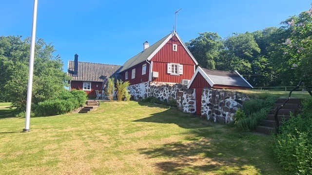
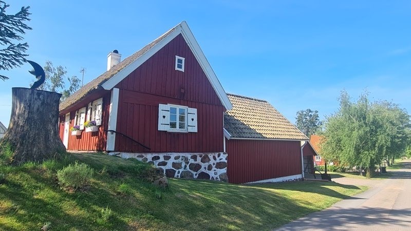
Bokesliden 87, Båstad
Nyheter och länkar - en bra startsida helt enkelt |Oculus lyx vitae
Written by Eleanor Moreland, Ph.D. Student Collaborator at Rice University
Perseverance has been busy exploring lower “Witch Hazel Hill,” an outcrop exposed on the edge of the Jezero crater rim. The outcrop is composed of alternating light and dark layers, and naturally, the team has been trying to understand the makeup of and relationships between the light and dark layers. A few weeks ago, we sampled one of the light-toned layers, which we discovered was made up of very small clasts, or fragments of rocks or minerals, at “Main River.” Since then, we have learned that the dark layers tend to be composed of larger clasts compared to the light layers, and we’ve been searching for a place to sample this coarser-grained rock type. Sometimes, these coarser-grained rocks also contain spherules, which are of great interest to the science team because they provide clues about the process that formed these layered rocks.
Perseverance first looked at a dark layer at “Puncheon Rock” with an abrasion. We then examined a dark layer at “Wreck Apple,” near “Sally’s Cove,” but we could not identify a suitable surface to abrade. So, while team members searched for other locations to study the coarse-grained units and spherules, Perseverance drove south to “Port Anson.”
Port Anson was intriguing because, from orbit, it showed a clear contact between the light layers of Witch Hazel Hill and a distinct unit below it. And, although the rocks below the Port Anson contact do show interesting compositional differences with those of Witch Hazel Hill, they weren’t the coarse-grained rocks we were looking for. We still performed an abrasion there, at Strong Island, before driving back up north for another attempt at investigating the coarser-grained rocks.
We aimed for “Pine Pond,” which neighbors “Dennis Pond,” to abrade at “Hare Bay.” With the data just coming down over the weekend, the team will be hard at work to figure out if we captured the coarse grains and spherules, and if it is representative of rocks we have seen before or not. The image below is a close-up of this most recent abrasion patch at Hare Bay — what do you think? Stay tuned to find out! Läs mer…
Written by Scott VanBommel, Planetary Scientist at Washington University
Earth planning date: Wednesday, April 23, 2025
I will start this blog with an apology, an apology because I suspect, by the end of this post, you, the reader, may have a craving for chocolate, or cake, or both. While we saw hints of it in the previous workspace, as captured by Susanne’s blog, today’s workspace featured prominent laminations throughout Curiosity’s sightlines, which presented the science team with the challenge of finding a safe place to utilize APXS (and MAHLI). Perhaps it was because of Easter last weekend, perhaps I needed an early lunch — whatever the cause, I could not shake the visual parallels between the rocks in our workspace, as captured in this blog’s image, and a many-layered-cake such as a Prinzregententorte.
The rover planners rose to the technical challenge, as they always do, and were ultimately able to find a safe area to place APXS on the top of the rock that is prominent just above and left of the center of today’s image. Combined with a green-light from SRAP, Curiosity now had its (cakey) target and could APXS it too.
Tosol’s APXS and MAHLI target, “Hale Telescope,” is named after the famous landmark located north-northwest of San Diego, California. I, for one, was not familiar with the history of this landmark, including how groundbreaking it was at the time of its development and commissioning through the 1920s, ‘30s, and ‘40s.
Curiosity’s plan tosol started with APXS and MAHLI of Hale Telescope. These activities were complemented by Mastcam images of “Puerto Suelo” and “Potrero Seco,” as well as long-distance imaging by ChemCam of “Torote Bowl,” nearly 1 kilometer (about 0.6 miles) away. Curiosity also imaged and conducted compositional analyses of the layered target “Fan Palm,” slightly offset from Hale Telescope, with LIBS. Our intrepid rover then completed a drive of about 23 meters (about 75 feet) in preparation for the three-sol weekend plan.
On the second sol of the current plan, Curiosity acquired Navcam images and a suprahorizon movie. The highlight of the second sol, however, arguably was an upgraded version of the AEGIS (Autonomous Exploration for Gathering Increased Science) activity where the rover will autonomously determine its own target to analyze with ChemCam while awaiting further instructions from Earth. The software upgrade will allow Curiosity’s team to know what target the rover chose to observe in time for us to make the weekend plan, even though the observation itself won’t happen on Mars until later.
Mars continues to offer stories written in stone, and like all good stories, the richness lies in the voices layered within. Or chocolate. The data aren’t down yet. Läs mer…
Written by Susanne Schwenzer, Planetary Geologist at The Open University
Earth planning date: Monday, 21st April 2025
It is Easter Monday, a bank holiday here in the United Kingdom. I am Science Operations Working Group Chair today, a role that is mainly focused on coordinating all the different planning activities on a given day, and ensuring all the numbers are communicated to everyone. And with that I mean making sure that everyone knows how much power we have and other housekeeping details. It’s a fun role, but on the more technical side of the mission, which means I don’t get to look at the rocks in the workspace as closely as my colleagues who are planning the activities of the instruments directly investigating the rocks. It’s a lot of fun to see how planning day after planning day things come together. But why am I doing this on a bank holiday, when I could well be on my sofa? I just was reminded in the hours before planning how much fun it actually is to spend a little more time looking at all the images – and not the usual hectic rush coming out of an almost complete work day (we start at 8 am PDT, which is 4 pm here in the UK!). So, I enjoyed the views of Mars, and I think Mars gave me a thumbs up for it, or better to say a little pointy ‘rock up’ in the middle of a sandy area, as you can see in the image above!
I am sure you noticed that our team has a lot to celebrate! Less than a month after the publication about alkanes made headlines in many news outlets, we have another big discovery from our rover, now 4518 sols on Mars: in three drill holes, the rover instruments detected the mineral siderite, a carbonate. That allowed a group of scientists from our team to piece together the carbon cycle of Mars. If you want to know more, the full story is here. I am looking forward to our next big discovery. Who knows that that is? Well, it would not be exploration, if we knew!
But today’s workspace looks intriguing with all its little laminae (the very fine layers) and its weathering patterns that look like a layered cake that little fingers have picked the icing off! (Maybe I had too many treats of the season this weekend? That’s for you to decide!) But then Mars did what it did so many times lately: we did not pass our slip risk assessment and therefore had to keep the arm stowed. I think there is a direct link between geologists getting exciting about all the many rocks, and a wheel ending up on one of them, making it unsafe to unstow the arm. There was a collective sigh of disappointment – and then we moved on to what we actually can do.
And that is a lot of imaging. As exciting as getting an APXS measurement and MAHLI images would be, Mastcam images, ChemCam chemistry and RMI images are exciting, too. The plan starts with three Mastcam activities to document the small troughs that form around some of the rocks. Those amount to 15 frames already, then we have a ten-frame mosaic on a target called “West Fork,” which is looking at rocks in the middle ground of the scenery and display interesting layering. Finally, a 84 frame mosaic will image Texoli, one of the large buttes in our neighbourhood, in all its beauty. It shows a series of interesting layers and structures, including some that might be akin to what we expect the boxwork structures to look like. Now, did you keep count? Yes, that’s 109 frames from Mastcam – and add the one for the documentation of the LIBS target, too, and Mastcam takes exactly 110 frames!
ChemCam is busy with a target called “Lake Poway,” which represents the bedrock around us. Also in the ChemCam activities is a long distance RMI upwards Mt Sharp to the Yardang unit. After the drive – more of that later – ChemCam as an automated observation, we call it AEGIS, where ChemCam uses a clever algorithm to pick its own target.
The drive will be very special today. As you may have seen, we are imaging our wheels in regular intervals to make sure that we are keeping track of the wear and tear that over 34 km of offroad driving on Mars have caused. For that, we need a very flat area and our rover drivers did locate one due West of the current rover positions. So, that’s where we will drive first, do the full MAHLI wheel imaging and then return to the originally planned path. That’s where we’ll do a MARDI image, post drive imaging to prepare the planning for the next sols, and the above mentioned AEGIS.
In addition to all the geologic investigations, there is continuous environmental monitoring ongoing. Curiosity will look at opacity and dust devils, and REMS will switch on regularly to measure wind speeds, humidity, temperature, ultraviolet radiation and pressure throughout the plan. Let’s not forget DAN, which monitors water and chlorine in the subsurface as we are driving along. It’s so easy to forget the ones that sit quietly in the back – but in this case, they have important data to contribute! Läs mer…
Written by Lucy Thompson, Planetary Geologist at University of New Brunswick
Earth planning date: Friday, April 18, 2025
As the APXS operations person today, I was hopeful that we could plan a compositional measurement after brushing one of the bedrock blocks in front of the rover. However, it soon became clear that the rover was not on stable enough ground to safely unstow the arm and place APXS and MAHLI. Silver linings though; by not having any arm movement in this plan, which requires significant energy, we were able to conserve power for what we hope will be a busy week of upcoming science activities as we drive towards our next high priority area of interest – the so-called boxwork formations. These are large resistant ridges identified from orbit, which may be the result of fracturing, fluid flow and alteration within the sulfate unit that we are traversing through. We plan to image them on approach to gain insights into their context.
Despite the loss of arm activities, we still have plenty of interesting observations planned for this 3-sol weekend. ChemCam will fire its laser at two separate rock targets, “Santa Ynez” and “Cahuilla”, which will also be captured with Mastcam documentation images. The targets are on two different bedrock blocks with the “Cahuilla” raster focused on a thin resistant layer. ChemCam will also use its remote imaging capabilities to obtain mosaics of the “Texoli” butte and another interesting feature, “Torote Bowl”. Mastcam will capture mosaics of “San Gabriel River” (an apparent angular contact) and of some sand troughs surrounding many of the bedrock blocks in this region. An image will also be acquired of a small, grey float pebble, “Piru Creek.”
The environmental science group was also able to plan a number of activities to catch up on their regular cadence, which has been impacted by the recent power constraints. We are acquiring Navcam line of sight observations (x2), suprahorizon movies (x2), a zenith movie and a 360 degree sky survey, as well as a Mastcam sky survey. Coordinated ChemCam passive sky and APXS atmospheric observations are also planned.
There is a ~19 m drive planned through this tricky terrain that will hopefully set us up for arm activities (APXS and MAHLI) in our new workspace next week. The plan is completed with standard RAD, DAN and REMS activities, as well as two MARDI images to record the terrain beneath the rover in the current and new workspace. Läs mer…
Written by Lauren Edgar, Planetary Geologist at USGS Astrogeology Science Center
Earth planning date: Monday, April 14, 2025
We all know the feeling: it’s Monday morning after a big weekend and you’re coming into the week wishing you’d had a little more time to rest and recharge. Well, Curiosity probably feels the same way today. Curiosity accomplished a lot over the weekend, including full contact science, a MAHLI stereo imaging test, testing the collection of ChemCam passive spectral data at the same time as data transmission with one of the orbiters, and some APXS and MAHLI calibration target activities, plus a long 57 m drive. It was great to see all of those activities in the plan and to see some great drive progress. But that means we’re a bit tight on power for today’s plan!
I was on shift as Long Term Planner today, and the team had to think carefully about science priorities to fit within our power limit for today’s plan, and how that will prepare us for the rest of the week. The team still managed to squeeze a lot of activities into today’s 2-sol plan. First, Curiosity will acquire Mastcam mosaics to investigate local stratigraphic relationships and diagenetic features. Then we’ll acquire some imaging to document the sandy troughs between bedrock blocks to monitor active surface processes. We’ll also take a Navcam mosaic to assess atmospheric dust. The science block includes a ChemCam LIBS observation on the bedrock target “Santa Margarita” and a long distance RMI mosaic of “Ghost Mountain” to look for possible boxwork structures. Then Curiosity will use the DRT, APXS and MAHLI to investigate the finely-laminated bedrock in our workspace at a target named “The Grotto.” We’ll also collect APXS and MAHLI data on a large nodule in the workspace named “Torrey Pines” (meanwhile the Torrey Pines here on Earth was shaking in today’s southern California earthquakes! All is well but it gave some of our team members an extra jolt of adrenaline right before the SOWG meeting). The second sol is focused on continuing our drive to the south and taking post-drive imaging to prepare for Wednesday’s plan.
Phew! Good job Curiosity, you made it through Monday. Läs mer…
Written by Abigail Fraeman, Planetary Geologist at NASA’s Jet Propulsion Laboratory
Earth planning date: Friday, April 11, 2025
Curiosity is continuing to book it to the potential boxwork structures. The rover drove over 50 meters on Wednesday, and we plan to drive more than 50 meters again in today’s plan thanks to an unusually good viewshed that allows us to see far ahead. We’ve been able to see glimpses of the boxwork structures in the distance for a few weeks now, and I am really excited about being able to plan long drives that get us closer and closer. What will we find when we reach them?
Power was on everyone’s mind as we put the plan together today. The science team had lots of amazing ideas about observations to collect from our current location, but we had to carefully plan and prioritize them to make sure we didn’t use too much power and leave the rover battery lower than we’d like for Monday’s plan. Winter on Mars certainly keeps us on our toes! We ended up putting together what I think is a pretty good set of activities for the weekend. MAHLI, APXS, and ChemCam will all work together to observe a flat rock in front of us named “Iron Mountain.” MAHLI will also do an experiment with this rock, testing different combinations of camera positions to see which produces the best data to help us generate 3D models of the rock’s surface. I know rocks don’t have feelings, but if they did, I hope Iron Mountain can use this time to feel a bit like a movie star on the red carpet, getting photographed from all angles. Mastcam will also be photographing the surroundings, working with ChemCam’s RMI imager to take images the ridge containing boxwork structures named “Ghost Mountain,” and taking some solo shots of targets in the foreground named “Redondo Flat,” “Silverwood Sanctuary,” and the oft photographed Gould Mesa. Navcam, REMS, and DAN round out the science plan with some environmental observations. We’ll be getting one more science and engineering hybrid observation when we collect ChemCam passive spectral data of the instrument’s calibration target in parallel with one of our communication passes. This observation is part of a series of tests we’re doing to run rover activities in parallel with these passes, and if successful, will allow us to be more even more power efficient in the future.
We’re also celebrating a soliday this weekend, which means we only have a two-sol plan instead of our usual three as the Mars and Earth time zones re-align for the next few weeks. I’m looking forward to seeing where Curiosity drives next week. Läs mer…