Date:
Author: Natarsha McPherson, PhD Candidate in Spatial Ecology, University of Adelaide
Original article: https://theconversation.com/the-nullarbor-is-riddled-with-wombat-and-rabbit-warrens-scientists-are-watching-them-from-space-249359
On the vast expanse of the Nullarbor Plain in South Australia, two very different creatures live side by side – but not always peacefully.
One is the southern hairy-nosed wombat, a slow-moving nocturnal digger that loves its underground burrows. The other is the European rabbit: a small and speedy invader that has spread across the continent, often wreaking environmental havoc and creating its own networks of tunnels.
How do we know where these semi-subterranean creatures live, and how many there are? The answer is from the sky.
In new research published in Australian Mammalogy, we show a way to detect wombats and rabbits using satellites that take pictures of our planet from space. By studying high-resolution images from the likes of Google Earth and Bing Maps, we can spot the telltale signs of the burrows and warrens these creatures dig into the ground.
Why is it any of our business where wombats and rabbits live?
Knowing where wombats and rabbits live is important for conservation.
Wombats are unique Australian marsupials that need protection. Rabbits are an invasive species that often damage the land, eating too much vegetation and eroding soil.
Finding their warrens can help scientists and wildlife managers to understand where they live. This in turn helps to make better decisions about protecting native species and controlling pests.
How do you spot a warren?
Imagine looking down at the world from the window of an aeroplane. You might easily see rivers and roads, and even buildings.
But would you spot a hole in the ground? That’s the challenge we faced in our study of satellite images.
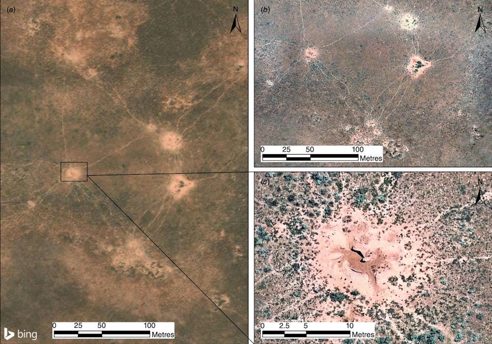
Bing Maps / McPherson & Ostendorf / Australian Mammalogy, CC BY-NC
As it turns out, wombat warrens are relatively easy to spot. They are quite large and have clear trails leading in and out. The digging leaves mounds of lighter-coloured soil.
Rabbit warrens are trickier to find. They are smaller, lack trails, and can blend in with bare patches of dirt.
How well did we do?
By comparing satellite images with surveys conducted on the ground, we figured out we could accurately detect about 82% of wombat warrens from the photos. We weren’t quite as good at rabbit warrens: we could only spot 49%. Small rabbit warrens were particularly easy to miss.
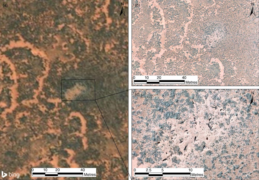
Bing Maps / McPherson & Ostendorf / Australian Mammalogy, CC BY-NC
One complicating issue was the fact that wombats and rabbits sometimes share the same burrow. Usually it’s the smaller, sneakier rabbits taking advantage of the large and sturdy tunnels dug by wombats.
This makes it even harder to figure out exactly who is living where. We could recognise shared warrens when we inspected them on the ground, but so far we can’t distinguish them from satellite photos.
What’s next?
Our research shows we can use satellites to map burrowing animal populations without ever setting foot in the outback. This saves time and money, and also reduces the the risk of disturbing wildlife while conducting research.
In the future, with higher-resolution satellite images and better software – using tools like machine learning – we may be able to detect and count burrows and warrens automatically. This could be a big change for wildlife conservation and pest control.
So next time you look up at the sky, remember that somewhere out there a satellite might be taking a picture of a sleepy wombat’s home – or a rabbit plotting its next move.